The Life Savers of Sandy Hook
With Special Feature - Galilee Life Saving Station
Like Penelope's merchant ship, many ships crashed on the shoals protecting Sandy Hook. Countless lives at sea have been lost here. Numbers so great, we will never know.
|
The Start of US Life Saving Service
New Jersey saw many shipwrecks on or near its shores in the 19th century. This played a key role in the founding of what became the U.S. Life-Saving Service. In 1848, Monmouth County Congressman William A. Newell reported to Congress that in a span of less than ten years, between 1839 and 1848, that 158 sailing vessels had been lost off the New Jersey coast.. Newell asked Congress to appropriate $10,000 to build eight “lifeboat stations” equipped with “surfboats, lifeboats, and other means for the preservation of life and property shipwrecked on the coast of New Jersey between Sandy Hook andLittle Egg Harbor.” Congress agreed, and the stations were completed one year later, in 1849. The lifesaving stations were spaced ten miles apart from Spermaceti Cove on Sandy Hook south to Long Beach Island. Each station housed rescue equipment that included a surfboat mounted on a wagon, a small line-throwing mortar, and a small enclosed metal lifeboat called a “lifecar.” The lifecar held up to six passengers and was used to haul them back to the beach using rope lines stretched from shore to shipwreck. |
Galilee Life Saving Station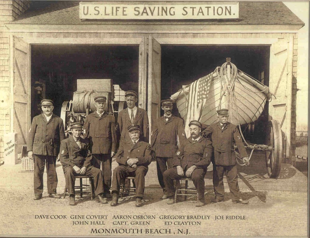
Photo credit: Michael Wilcox.
Galilee Life-Saving Station (GLSS) was #4 along the coast starting with Sandy Hook Lighthouse #1, Spermaceti Cove #2 (currently operating as a museum), Sea Bright #3 and Galilee #4. GLSS is in present day Monmouth Beach and exists today as the Monmouth Beach Cultural Center. .
|
Congress continued to make additional appropriations to create more stations. The federal lifesaving establishment was growing, but without anyone at the stations to care for them, they fell into disrepair. Local volunteers performed the rescues, but they often had to travel long distances just to get to a station, and then to a shipwreck. Sometimes they arrived too late to help shipwreck victims.
Rescue Equipment
When a shipwreck occurred, lifesavers preferred using wooden rescue boats called surfboats. These could be launched and rowed quickly from the beach and held up to 12 passengers. However, some storms were so powerful a boat could not be used, so the beach apparatus had to be relied upon to perform the rescue.
Lieutenant David A. Lyle, an officer in the U.S. Army Ordnance Department, developed a long range line-throwing gun for the Life-Saving Service. He field-tested his small bronze cannon at the Army’s Sandy Hook Proving Ground in 1877, and the Lyle Gun was officially put into service the following year.
This gun was a great lifesaving innovation. It could shoot a shot- line over 500 yards to make contact with a shipwreck. A shipwrecked crew hauled in the shot-line to bring heavier lines out to the ship. With lines stretching from ship to shore, the lifesavers pulled a breeches buoy out to the wreck so people could be saved by hauling them back to the shore. The Lyle gun was so reliable and practical that no other gun ever replaced it for shipwreck rescues during the Life Saving Service era.
The boat wagon and beach apparatus cart were pulled from a station by a horse and lifesaving crew to a shipwreck in the worst kind of weather imaginable. During severe storms two lifesaving crews would sometimes work together.
The boat wagon and beach apparatus cart were pulled from a station by a horse and lifesaving crew to a shipwreck in the worst kind of weather imaginable. During severe storms two lifesaving crews would sometimes work together.
U.S. Life Saving Station #4, Galilee
by Michael Wilcox
Galilee Life-Saving Station is of particular relevance to me as I have direct family ties to its famed history.
|
In 1849, just over 200 years when Penelope's merchant shipped crashed near Sandy Hook, Congress formally created Life-Saving Stations (USLSS) for the purpose of protecting life along this dangerous stretch of ocean.. This would be the beginning of what is now our U.S. Coast Guard.
In the past there was a life-saving station (USLSS) near Sandy Hook Lighthouse, with another at Spermaceti Cove, and another near Sea Bright. The USLSS surfmen had horse-drawn wagons they used on the beaches to haul boats and rescue people from ships that foundered trying to get into New York harbors before there were radios and navigation aids. The photo to the right is a courtesy of my great-grandfather Joseph Riddle (featured right). He died 18 years before I was born. My father talked about him so much that I felt I knew him. In the same photo is the brother of Joseph Riddle, Captain Holmes Riddle (1852-1918). Uncle Holmes started working for the Revenue Cutter Service (RCS) at the Normandie Station, which became the Normandie Station of USLSS. He worked there for 30 years, became Surfman #1 and finally acting captain of the station. |
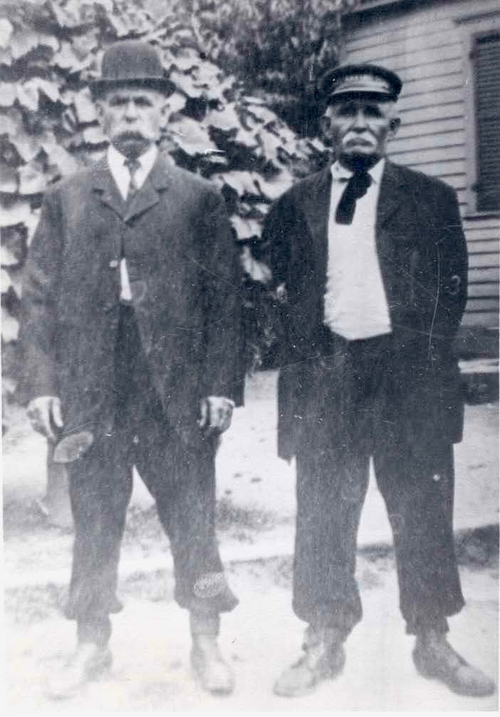
l-r: Capt. Holmes Riddle, Joe Riddle.
|
The mission of the RCS was the collection of import duties from ships arriving from abroad and bound for ports in Red Bank, Oceanport, and Long Branch. The RCS was established by President George Washington in 1790 when the inlet to the Shrewsbury River was across from Middletown.
The RCS station at Normandie in Sea Bright had done its job of collecting import duties for ships entering New Jersey from abroad, but then shifting sands, plus the steamboats and railroads from New York, put it out of business. By 1870 most of their activity shifted to search and rescue for stricken vessels entering New York harbor, not collecting taxes. So when the U.S. Life-Saving Service was formed, Normandie made a natural transition from USRCS to USLSS.
The RCS station at Normandie in Sea Bright had done its job of collecting import duties for ships entering New Jersey from abroad, but then shifting sands, plus the steamboats and railroads from New York, put it out of business. By 1870 most of their activity shifted to search and rescue for stricken vessels entering New York harbor, not collecting taxes. So when the U.S. Life-Saving Service was formed, Normandie made a natural transition from USRCS to USLSS.
That is when my great-uncle Holmes Riddle made the switch from RCS to LSS. His brother Joe joined the LSS later, during the 1880s. I think he started at Spermaceti Cove, and switched to Galilee around 1890.
Whenever there was a storm or low visibility due to fog, the LSS surfmen walked the beach, looking for ships in trouble. In order to maintain the watch, they were on a coordinated schedule that required the surfmen to cover their stretch of beach and meet each other at an appointed time. When meeting they would exchange metal placards about the size of a belt buckle, to prove they had covered their stretch of the coast (and not laid down for a nap or popped into a saloon). It gives me pleasure to think that sometimes, my great-grandfather Joe Riddle from Galilee would meet his brother Holmes Riddle from Normandie and exchange placards in the middle of the night, just watching for ships in trouble.
Whenever there was a storm or low visibility due to fog, the LSS surfmen walked the beach, looking for ships in trouble. In order to maintain the watch, they were on a coordinated schedule that required the surfmen to cover their stretch of beach and meet each other at an appointed time. When meeting they would exchange metal placards about the size of a belt buckle, to prove they had covered their stretch of the coast (and not laid down for a nap or popped into a saloon). It gives me pleasure to think that sometimes, my great-grandfather Joe Riddle from Galilee would meet his brother Holmes Riddle from Normandie and exchange placards in the middle of the night, just watching for ships in trouble.
The Normandie station is no longer there, but its location in can be seen on Google Maps as Normandie Place, just east of the Navesink River. It was a railroad station on the NJ Southern Railway in those days.
Holmes and his brother Joe lived on Riddle Avenue (of course) in North Long Branch for many years. They rode bicycles from Riddle Avenue across the Patten Avenue bridge into Monmouth Beach, to the Galilee train station, and left their bikes at the Galilee USLSS. Joe went to work and Holmes got on the train for the short trip up to the Normandie Station.
You may ask how I know they rode bicycles rather than walking or horse-drawn wagon. I know because in the photo to the right with Holmes on the left and Joe on the right, it's easy to see that they had clips around their ankles to keep their pantlegs from catching in their bicycle chains. Michael is also a 9th great-grandson of Penelope, through her son Jonathan born in 1660.
Sandy Hook Peninsula Taking Shape
|
The Sandy Hook lighthouse has witnessed many changes over the years. The greatest change has been to its location relative to Sandy Hook peninsula itself.
In 1764, the lighthouse stood just 500 feet from the tip of Sandy Hook. Ocean currents continued to move sand up the coast (littoral drift), extending the tip further out into the harbor, so that by 1864, the lighthouse stood about 4,000 feet from the tip. The lighthouse now stands about one and one half miles (7,920 feet) from the northern end of Sandy Hook.
To illustrations below indicate the change to Sandy Hook Peninsula. For an expanded view, click on the image itself. |
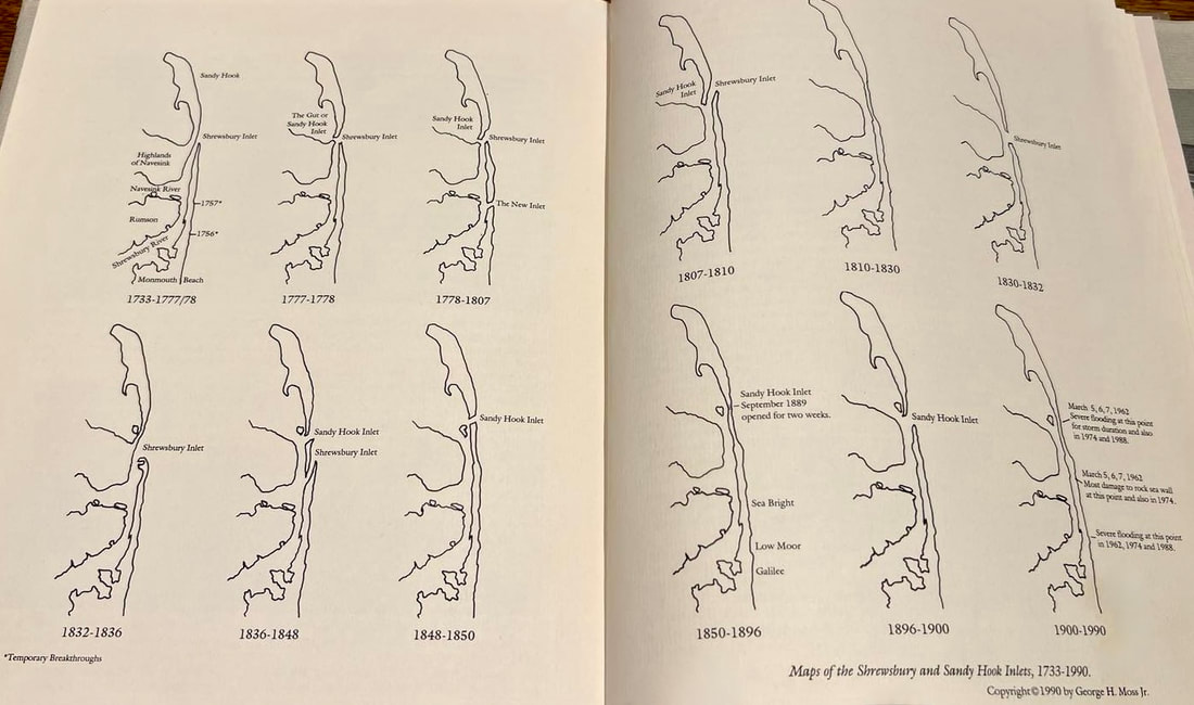
Maps of Sandy Hook Peninsula are from Nauvoo to the Hook, by George Moss.
|
As you can se, for most of its history before 1900 there was a shipping inlet somewhere between Middletown and Rumnson. New York harbor had its own customs operations. But, without a customs office down in Monmouth County, inbound freighters could avoid collection of import duties
Contributing Author, Michael Wilcox